HYDROGEOLOGY
GEOMIN staff members provide services in a wide range of hydrogeological workings:
HYDROGEOLOGICAL MAPPING
Compilation of maps on different scales from regional level (1:200000, 1:100000) through medium scale maps (1:50000, 1:25000) to small scale maps (1:10000, 1:5000 and smaller). Hydrogeological maps are particularly applicable in the territorial planning, groundwater protection, risk management, and as part of the grounds for environmental risk assessments.
-
Compilation of regional and detailed maps
-
Exploitation of airborne photographs
-
Exploitation of satellite images
-
Field reconnaissance
-
Water analyses
-
Groundwater chemism maps
-
Assessment of effects on and limitation of mining caused by the presence of groundwater
-
Identification of inflows to mining plants
-
Mining plant drainage projects
-
Assessment of mining plant drainage effects on the surrounding water sources and hydrogeological environment
- Hydrogeological study
- Field examination
- Geophysical survey
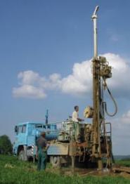
- Well drilling
- Hydrodynamic (pumping and recovery) tests
- Calculation of new water source yield and proposal of utilization
- Water quality analysis
- Delimitation of protective zones
- The work includes a proposal of a new water source protection technique, taking into consideration the source quality and yield.
Integral part of work is
proposal of manner of new water resource protection from point of view of its
quality as well as yield.
The sense of delimitation of protection zones is to protect the yield, quality and healthy condition of a water source. The proposal to delimitate protective zones is included in final reports on the installation of new water sources. These proposals are also made for older water sources, for which protection zones have not been delimitated yet, or which have not been used for drinking water captation yet and require protection.
-
Proposals of protective zones in accordance with the valid legislation
-
Proposals of specific protection of water sources against pollution
-
Proposals of specific protection of water sources against negative effects on the water level and yield
-
Assessment of risks posed to yield, quality or healthy condition of a water source
-
Recommendations for the management in the particular water source protection zones The proposals of water source protective zones include the data on climate, geomorphology, hydrology, hydrogeology and geology and other protective zones.
The studies are based on retrievals of geological and hydrogeological data, and are followed by field reconnaissance and identification of promising locations for the installation of new groundwater sources.
The studies are concluded by a proposal of further exploration for the identification and installation of a groundwater source.
-
Grounds for the assessment of possibilities of water supply for the municipalities, businesses and other objects
-
Field examination
-
Exploitation of airborne photographs
-
Exploitation of satellite photographs
-
Geophysical survey
-
Study of groundwater effects on residential agglomerations (effects on building structures)


